
Gravity Nu
Software package for visualization of gravitational force effects between N objects.
In order to predict/calculate object data (position and velocity) in future or past time (within limits of calculation) one need object mass, initial position and initial velocity vector at some initial moment of time.
Data is calculated and displayed in SI units (second, meter, kg, meter/second etc.). Position data is defined in (x,y,z) components and velocity data is defined in (x,y,z) vector components in Cartesian coordinate system.
There is no limitation in parameters - object will behave just like they behave in the real world, within variables, calculation and display limitations.
Project and object data can be defined via software interface (Project and Impulse Editor).
TO START THE QUICK EVALUATION :
1. Start GRAVITY Nu
2. CLICK on OPEN PROJECT BUTTON
3. Select START BUTTON from MAIN DIALOG
TO NAVIGATE IN 3D WINDOW :
ZOOM (CHANGE YOUR DISTANCE FROM THE SELECTED OBJECT)
rotate mouse WHEEL
ROTATE AROUND THE SELECTED OBJECT
press and hold WHEEL (third) mouse button while moving mouse
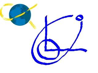
There are three ways of objects data graphical interpretation :
1. Line from origin (x=0,y=0,z=0) to selected object, in blue colour
2. Trail consisting of the last 100 position points in yellow colour. Duration of trail (object position history) is 100/FPS seconds of computer time (NOT object time).
3. Textured sphere representing objects, with selected texture image.
Initial texture image is supplied - def.bmp . There are also some texture images in ‘SOLAR SYSTEM’ folder but you can also try your own texture images; recommended size is 1024x512 pixels but you can also try other sizes.
NOTES:
In order to predict/calculate object data (position and velocity) in future or past time (within limits of calculation) one need object mass, initial position and initial velocity vector at some initial moment of time.
Data is calculated and displayed in SI units (second, meter, kg, meter/second etc.). Position data is defined in (x,y,z) components and velocity data is defined in (x,y,z) vector components in Cartesian coordinate system.
There is no limitation in parameters - object will behave just like they behave in the real world, within variables, calculation and display limitations.
Project and object data can be defined via software interface (Project and Impulse Editor).
TO START THE QUICK EVALUATION :
1. Start GRAVITY Nu
2. CLICK on OPEN PROJECT BUTTON
3. Select START BUTTON from MAIN DIALOG
TO NAVIGATE IN 3D WINDOW :
ZOOM (CHANGE YOUR DISTANCE FROM THE SELECTED OBJECT)
rotate mouse WHEEL
ROTATE AROUND THE SELECTED OBJECT
press and hold WHEEL (third) mouse button while moving mouse
There are three ways of objects data graphical interpretation :
1. Line from origin (x=0,y=0,z=0) to selected object, in blue colour
2. Trail consisting of the last 100 position points in yellow colour. Duration of trail (object position history) is 100/FPS seconds of computer time (NOT object time).
3. Textured sphere representing objects, with selected texture image.
Initial texture image is supplied - def.bmp . There are also some texture images in ‘SOLAR SYSTEM’ folder but you can also try your own texture images; recommended size is 1024x512 pixels but you can also try other sizes.
NOTES:
- data numbers are formatted in scientific notation (example : 1.123456123456E12) with 12 digit precision after decimal separator and variable type is FLOAT (EXT) with range of : +/- 4.19e-307 to 1.79e308
- sphere radius is calculated from object mass and density
- once PROCESS button is selected calculation will run until t=STOP TIME (from TIME DIALOG))
- if STOP TIME is less then current time then the process will run backwards in time
- collision checking can be ON or OFF - if it is OFF then object are treated as point mass
- some (or all) of the display modes can be switched off from the OPTIONS DIALOG
- calculation time is performed as fast as possible (considering actual processor) while display update rate is selectable up to 50 times per second (every 20 ms) - if your computer can handle this speed
- UNITS for data are : x,y,z position in m, x,y,z velocity in m/s, mass in kg, density in kg/m3
- position and velocities data is defined in (x,y,z) vector components in Cartesian coordinate system.
- about dt (integration time step) : the smaller dt is the precision is better but also calculation lasts longer in your /PC/ time
- about precision and accuracy : as an example (test we performed), accuracy of earth position in 4 years forward calculation with dt=1 (s) is +-50 000 m (or +-50 km) - compared with JPL Horizons (NASA) ephemeris data; PC processing time was about 30 minutes